This blog was prepared by intrepid and passionate avocational archaeologists Jim Gloor and Carol Reynolds.
WHAT MEASURES 13.4 FEET X 13.2 FEET,
CONTAINS OVER 1000 LBS OF HINGED OYSTER SHELLS,
AND RESIDES AT TODDSBURY?
The excavations continue at Toddsbury (44GL0264), a 17th– to 19th– century historic plantation located on the Middle Peninsula along the west bank of the North River in Gloucester County, Virginia. First, a little background. In September of 2015, a Fairfield Foundation blog described a memorable event ranking toward the top of the list of so many other memorable Fairfield Foundation events. “Five buildings…less than a day… a feat we will likely never experience again” is the way the author described it. The excitement was due to the fact that over the course of one day, participants had identified five separate brick foundations located in a line running from the Toddsbury manor house east to the North River, a complex of foundations that they had no idea existed the day before the event. “What were these buildings?” “Who lived there?” “What can this tell us about the past?” were several of the questions that came to mind, to which the blogger gave a short but not very satisfying answer: “We don’t know.”
Fast forward to 2018. Intrepid Archeological Society of Virginia certified archaeology technicians Carol Reynolds and Jim Gloor, along with assistance from Fairfield Foundation staff and volunteers, embarked on what has become a multi-year project to study each of the five building foundations. We wanted to try to answer the questions posed in the 2015 blog – “What are these buildings?” “Who lived there?” “What can they tell us about the past?” While this is certainly a project in progress, we have begun to learn some answers about Building 4. Like so many other things, though, each answer seems to lead to more questions.
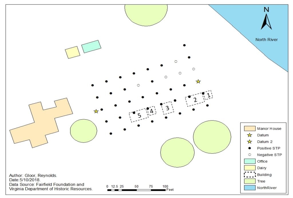
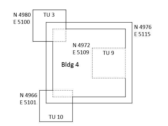
Building 4 is one of the smaller of the five foundations (one reason why we picked this building to study), measuring approximately 13 feet square. Based on its size, and its location near the Building 5 foundation thought most likely to be a kitchen, we expected that it might be a smokehouse. Following the 2015 shovel test survey, one test unit was excavated which exposed the northwest corner of the foundation of Building 4. Interestingly, the interior of the building contained a large number of oyster and clam shells, which was interpreted at the time as a likely filled-in cellar.
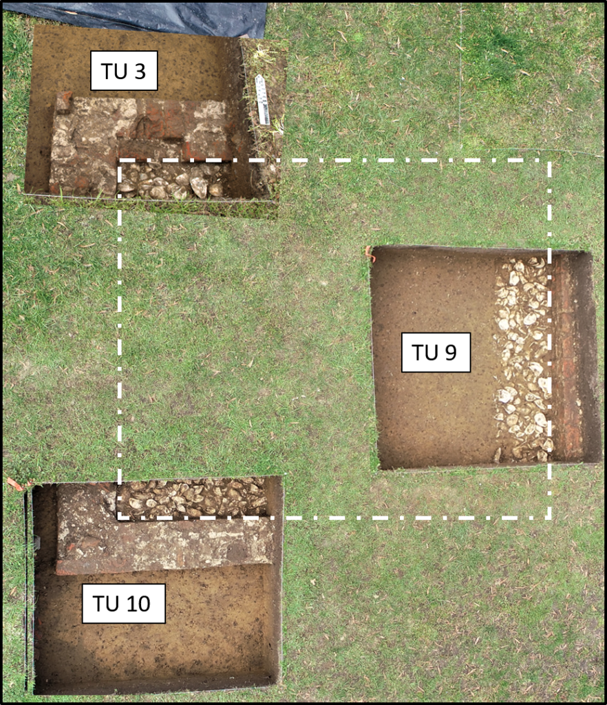
In April 2018, we came back to do more work on Building 4. The artifacts recovered in the 2015 test unit were analyzed, and two more test units excavated.
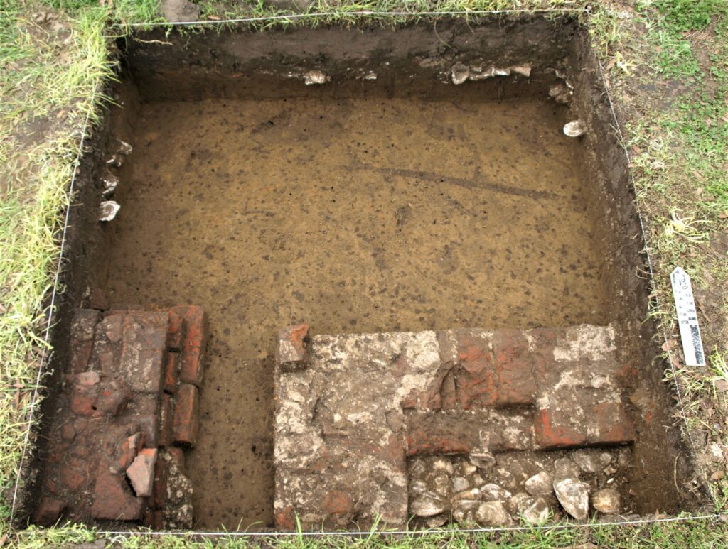
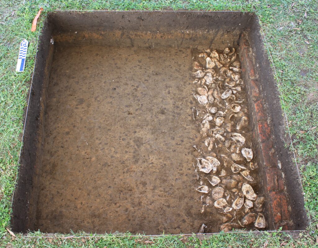
When we excavated Test Unit 9, located along the east wall of the foundation, we found an unusual combination of architectural features. First, there was a very dense cap of clay occupying the western part of the test unit. Interestingly, it came to within 1-2 feet of the foundation wall and stopped.
When this clay cap was removed and the test unit excavated further, we uncovered a trench along the inside of the foundation wall filled with a 0.5-foot-thick layer of oyster and clam shells.
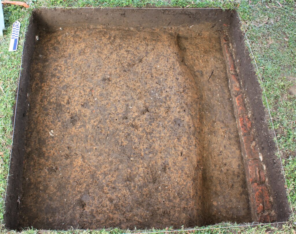
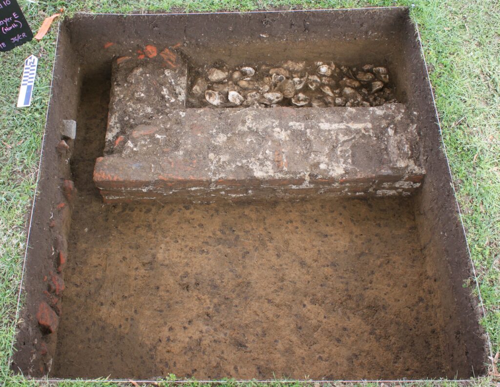
When we excavated Test Unit 10, we found the southwest corner of the foundation, and similar to what was found in Test Unit 3, it was filled with oyster and clam shells.
oyster and clam shells.
Probing confirmed that the shell-filled trench continued along the entire inside periphery of the foundation. We weighed the oyster and clam shells recovered from the test units, and calculated that greater than 1,000 lbs. of shell were required to fill the entire trench.
An important part of our investigation was to determine the purpose of the building and the period it was used. Over half of the nearly 3,000 artifacts recovered from the three test units were animal bone fragments and teeth, predominantly pig. While the lack of a firebox or firepit makes it unlikely that Building 4 was used as a smokehouse, the large number of bones suggests it was used in meat processing or storage. Another possibility is that Building 4 was used as a dairy. The clay cap may have been paved with a layer of dry-laid (no mortar) brick, providing an easily cleaned, solid floor. With the shell trench occupying the periphery, this ingenious design would improve drainage of water from a building with an otherwise relatively impermeable floor in which ice was stored to maintain a cool temperature.
Ceramic sherds and other artifacts recovered from under the clay cap or within the shell-filled trench almost certainly would have been discarded there during the building’s construction, providing a clue as to when it was built. White salt-glazed stoneware and Buckley ware, ceramic types popular during the mid-18th -century, were recovered from within the shell-filled trench, leading us to conclude that the building was likely constructed during that period. Though its date of destruction was not clear from the artifacts, based on period maps it appears that all five of the buildings were gone by the 1870s.
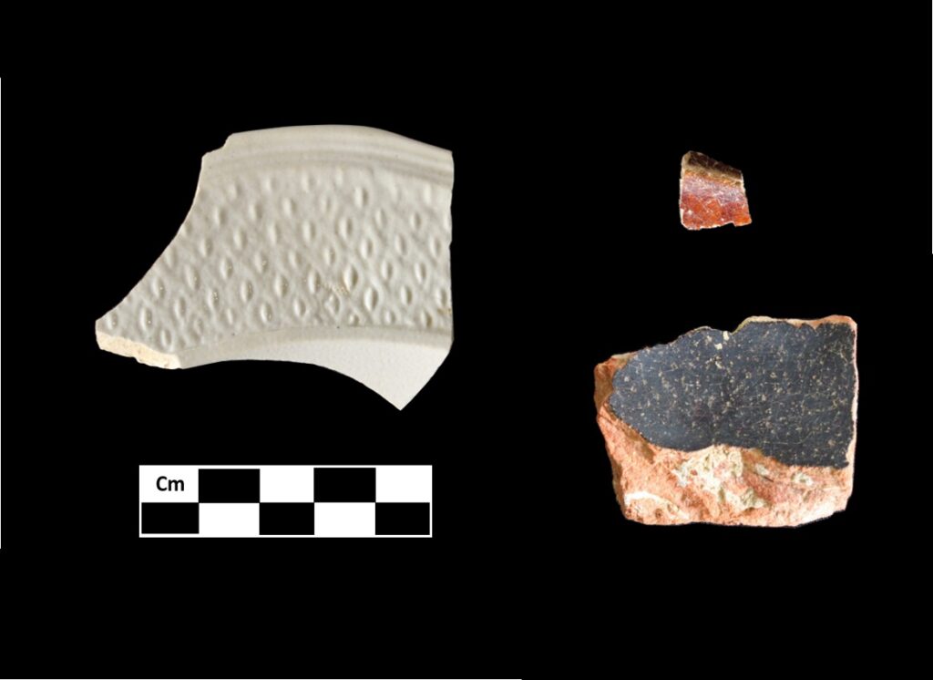
Buckley ware (bottom right).
When we put all these findings together, we come up with an interesting structure. It appears that the floor of Building 4 had a layer of clay occupying the center, surrounded by a trench filled with shells. While we aren’t certain, we think it is likely that this floor was paved. The clay cap would have provided a solid support for a brick floor, and the shell-filled peripheral trench would have provided a way for trapped water to drain from the building. Its small size, and lack of heat source implies that it was not used as a residence, and its unusual features suggest it was not just a storage building. What other interpretations might explain this building’s quirks? We welcome you to share your thoughts about this unusual architectural feature.
Working at Toddsbury has been an amazing experience, allowing us to immerse ourselves, at least for a time, in the 18th century. We are excited to continue the work of exploring this wonderful historic resource, and we can’t wait to see what new things we will find.
You are so very thorough in your explanations. Thank you. Questions and more questions. It’s all quite fascinating. I am hopeful you will come to a conclusion to all of your questions put forth.
Thanks for the excellent and interesting article.
How great that the Toddsbury owners are supporting this research.
And sending a short article about each of the 5 structures is engaging….like reading chapters in a book.
Well done.