The Fairfield Foundation

  • Home
  • The Blog
    • Education
    • Archaeology
    • Preservation
    • 3D Model
    • Events
    • Drone
    • All Categories
  • Get Involved
    • Membership & Donations
    • Archaeology and Preservation Workshops
    • Volunteer Opportunities
    • Internships and Fellowships
    • Fairfield Archaeology Summer Camps 2025
  • Archaeology
    • Fairfield Plantation Virtual Museum
  • Preservation
  • Education
    • Fairfield Plantation Virtual Museum
  • Visit Us
    • The Center for Archaeology, Preservation and Education (C.A.P.E.)
    • Fairfield Archaeology Park
    • Rosewell Ruin and Visitor Center
    • Timberneck
    • Walter Reed Birthplace
You are here: Home / Archaeology / Mapping Buildings and Burials at Gloucester Town

July 16, 2013 By Fairfield Foundation

Mapping Buildings and Burials at Gloucester Town

Confederate fortifications at Gloucester Point, Va., opposite Yorktown, VaWhat happens to archaeological collections and associated documentation when the dig is over? Two weeks ago, fellow Colleen Betti wrote about her analysis of collections from the large slave quarter yards and midden at Fairfield (click here to read Colleen’s blog). Colleen’s research will culminate in a senior honor’s thesis at the College of William and Mary, which will be available to future researchers through Swem library. In a similar way, salvage and contract archaeology often concludes with a comprehensive technical report. In Virginia, these reports are available in the Department of Historical Resources (DHR) archives in Richmond. Archaeologists planning new field projects consult these site reports in order to get a glimpse of what other researchers learned and perhaps what they can expect from excavations. But what happens when numerous organizations and contract firms have excavated in the same area? It becomes much more difficult to piece together the history of a place and its residents unless all the various research has been synthesized.

Over the past year and a half, I have been working with the Fairfield Foundation to research the history and archaeology of Gloucester Point. In particular, we are interested in Gloucester Town, a thriving colonial port located on the York River and the present-day site of the Virginia Institute of Marine Science (VIMS). Gloucester Town’s history of archaeological excavation extends back decades, primarily spurred by the expansion of the VIMS campus. These efforts led the placement of the Gloucester Point Archaeological District on the National Register of Historic Places in 1985. As a colonial port town, it has great comparative potential with sites like Colchester, recently excavated by Fairfax County archaeologists, and Yorktown, just across the river. Our goal is to add to the extensive body of research on Gloucester Point, writing “biographies” of Gloucester Town residents, overlaying historic plat maps on the landscape, and relocating previously-excavated archaeological features using GIS.

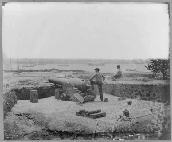
The high density of human burials is an endemic problem for archaeologists at Gloucester Point. While some contract firms elected to shift construction in order to preserve burials in situ, other firms fully excavated human remains, taking advantage of their research potential. Between 1983 and 2005, more than thirty burials were uncovered within the confines of historic Gloucester Town. My goal? Map each burial location – whether or not an individual is still interred on that site – in order to preserve extant human burials and determine known burial areas. The challenge? Mapping technology in the 1980s and 90s doesn’t come close to what we use today. I scanned site maps from the DHR, geo-referencing them (transforming them to a known coordinate system using a set of control points) in ArcGIS. I then digitized burial features, entering reference data in an associated table. The result? A clean map of burial locations on the VIMS campus, indicating key areas of historic burial concentrations. In particular, I note an area where seventeenth- and eighteenth-century Gloucester Town inhabitants were interred, a Revolutionary War era cemetery associated with Cornwallis’ siege of Yorktown and Gloucester Town, and a nineteenth-century burying ground postdating Gloucester Town.

Laura's Gloucester Town GIS Aerial view of Gloucester Point VIMS campus, with burial locations indicated

Beyond these goals, I have been researching the mortuary contexts and skeletal biology of individuals interred at Gloucester Point, contextualizing data using social history – a research model I take from Julie King and Douglas Ubelaker’s report at Patuxent Point, Maryland. I hope that this research – and the contributions of other Fairfield Foundation staff and volunteers – will add to the rich history of Gloucester and the Chesapeake region.

We welcome your comments and questions about the archaeology of Gloucester Town and the Gloucester Point area.  Much has been researched and written about this area, and we hope to add more content to this discussion in the near future that will help synthesize all the existing information out there about this significant place.

We extend our thanks to Laura Masur for conducting this research and preparing this blog.

Filed Under: Archaeology, Preservation Tagged With: archaeology, Gloucester Point, Gloucester Town

Comments

  1. k. smith says

    April 4, 2016 at 12:36 pm

    Thane,
    Have you found any colono ware at the Fairfield dig site. Thanks for the information on cowrie shells.
    I am writing an article for our chapter plow zone news letter.
    Thanks.
    kirbys2@comcast.net

  2. val coleman says

    August 16, 2017 at 2:10 pm

    I am trying to find the grave of my ancestor Robert Coleman of Mobjack Bay, who arrived at Tyndall’s point in 1638. Are there any tombstones from the period of the mid to late 1600’s?

  3. Emily Pentecost says

    October 11, 2017 at 12:31 pm

    My ancestor, John Mixon II, had land joining the land of Maj. Lewis Burwell in the Carter Creek area of Gloucester, Co, VA and bought Lot #11 in the newly formed Gloucestertowne located at the mouth of the York River. He died 20 Dec 1710 in Gloucester, Co. Any information on the lot owners or the burial section containing the 1710 time period?
    Thanks,

    • Fairfield Foundation says

      November 25, 2017 at 3:38 pm

      Emily, please keep in touch as our work on the site progresses. We anticipate a substantial paper presentation (illustrated) on our work for a conference in early January 2018 and would be happy to share that with you once it is presented. You can reach us at fairfield@fairfieldfoundation.org. The final report, which might be of most use to you, won’t be out until later in 2018 at the earliest, so please be patient with us and know that we’re interested in keeping you informed.

Get on the list!

Sign up to receive email updates and to hear what's going on with us!

Blog Categories

  • 3D model (6)
  • Archaeology (99)
  • drone (6)
  • Education (105)
  • Events (45)
  • History (21)
  • Preservation (110)
  • Uncategorized (4)

From the blog

  • Remembering George Wesley Catlett February 27, 2025
  • Wood’s Mill: an Overlooked Chapter of Gloucester Hall’s History December 2, 2024
  • The Revolutionary World of Lewis Burwell July 2, 2024
  • Lives from the Catlett Family Cemetery at Timberneck: Robert, Mary, and John Thruston January 31, 2024
  • “The best church I have seen in the country” Excavations in search of the 17th-century Abingdon Church January 12, 2024

Center for Archaeology, Preservation and Education (CAPE)

Opening Hours:

Grounds are always open to the public to view the building exterior and signage. The CAPE is open for tours on Thursdays from 10 a.m. to 4 p.m. and at other times by appointment. Lab nights at the CAPE are on 1st and 3rd Tuesdays from 6-9pm.
Address: 6783 Main Street Gloucester, VA 23061

News From Our Blog

  • Remembering George Wesley Catlett February 27, 2025
  • Wood’s Mill: an Overlooked Chapter of Gloucester Hall’s History December 2, 2024
  • The Revolutionary World of Lewis Burwell July 2, 2024

Looking for Something?

Contact Us

The Fairfield Foundation's mission is to promote and involve the public in hands-on archaeology, preservation and education activities within Virginia’s Middle Peninsula and surrounding areas. We are a 501(c)3 not-for-profit organization offering public programs, research opportunities and outreach activities since 2000. We operate five properties in Gloucester County: Fairfield Archaeology Park, Timberneck House at Machicomoco, Edge Hill Texaco (the C.A.P.E.), Rosewell Ruins and Visitor Center, and Walter Reed birthplace. For more information about us and other historic resources on the Middle Peninsula or to arrange presentations on a variety of topics related to local history and archaeology, please contact us. Check out the calendar for upcoming activities.
The Fairfield Foundation
P.O. Box 157 White Marsh VA 23183
Phone:
(804) 815-4467
Email:
fairfield@fairfieldfoundation.org
  • Facebook
  • Instagram
  • Twitter

Copyright Fairfield Foundation © 2025 | Log in